
Civil and environmental engineering Professor Erin Hestir’s proposal for a unique system of mapping mercury in the waters of the San Francisco Delta has won her and her team of collaborators a $1.7 million grant from the California Department of Fish and Wildlife (CDFW).
The CDFW is dividing up almost $28 million generated by Proposition 1 bond sales, the result of the Water Quality, Supply and Infrastructure Improvement Act voters approved in 2014. Hestir’s three-year project is one of 24 Restoration Grant programs approved for this year.
She and her colleagues at the U.S. Geological Survey in Menlo Park and the USGS California Water Science Center in Sacramento, are developing rapid, easy-to-use techniques to analyze the amount of mercury and methylmercury in the surface waters of the San Francisco Bay Delta.
“It’s typically a very expensive undertaking, but officials are concerned about the amount of mercury and methylmercury in the Delta, and they take the monitoring and measurements very seriously,” Hestir said.
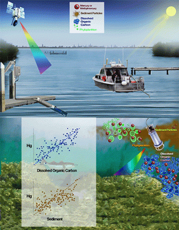
To enhance the measuring and monitoring programs already in place, Hestir’s team will develop techniques using optical sensors that reflect visible light off the water to infer the invisible mercury within the water. The sensors can be used for constant and/or rapid on-the-spot monitoring and will coordinate with space-based satellite data to create high-resolution temporal and spatial maps of the mercury.
Mercury is a naturally occurring element. But when it is in a special form, called methylmercury, it can accumulate in fish tissue, posing a well-known hazard to fish and human health. Methylmercury is created by microbes living in the water and in wetlands. The Delta is of particular concern because mercury, called “quicksilver” by the 49ers, was used during the Gold Rush and remains in the sediment.
“Now that many large-scale wetland restoration projects are proposed or underway in the Delta, there is concern about whether an unintended consequence is more methylmercury for the Delta,” Hestir said. “Our information will help people understand how big a problem it is.”
She and her partners at the USGS will work to hone the accuracy of the sensors and mapping process to answer questions about how wetlands restoration will affect mercury levels and better understand the transportation and fate of mercury throughout the Delta.
“Someday, these kinds of systems and maps might be able to be used to develop warning systems about high concentrations of mercury around the Delta or in other places around the world,” Hestir said. “For now, though, we’re going to focus on creating the systems and making sure they are as reliable as possible.”
Hestir, who runs the Earth Observation and Remote Sensing Lab at UC Merced, joined the campus a year ago from North Carolina State University in Raleigh. She is part of the Environmental Systems graduate group through the School of Engineering, faculty advisor to the Center for Information Technology Research in the Interest of Society (CITRIS) and an affiliate of the Sierra Nevada Research Institute.
“Hestir's research is testament to the high-caliber research being led by UC Merced,” CITRIS Director Professor Joshua Viers said. “This approach, developing and deploying the latest technology in environmental sensing, is precisely what is needed to solve our region's most pressing resource-management problems and to train our students to be tomorrow's leaders in science and engineering.”


